| References for 1968 Geologic Maps |
| Sources of Geologic Information |
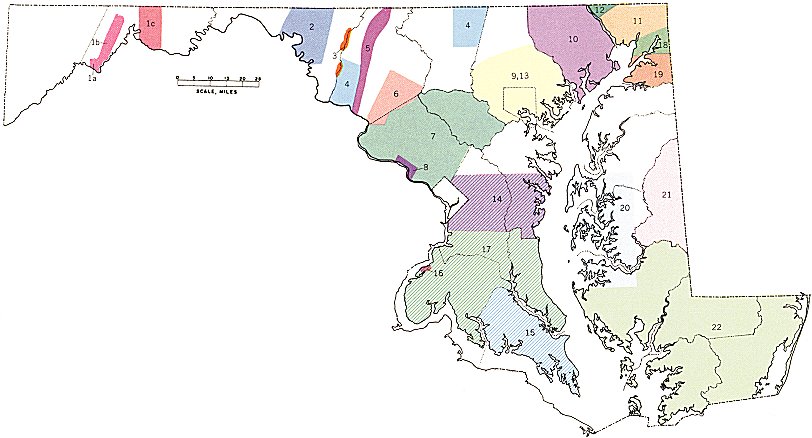 |
| A. County Geologic Maps of Maryland Geological
Survey (scale 1/62,500): Allegany (1956), Anne Arundel (1916), Baltimore (1925), Calvert (1903), Carroll (1928), Cecil (1902), Charles (1999), Frederick (1998), Garrett (1953), Harford (in preparation), Howard (1940), Kent (1915), Montgomery (1959), Prince Georges (1951), Queen Annes (1915), St. Marys (1903), Talbot (1916), and Washington (1941). These maps are not shown on index map, with the exception of Harford County. No county geologic maps exist for Caroline, Dorchester, Somerset, Wicomico, and Worcester Counties. |
| B. Sources other than published county geologic maps. (Number refers to area of map for which the reference was used.) |
| 1. (a) Dennison, J. M., and Naegele, O. D., 196S, Structure of Devonian
Strata along Allegheny Front from Corriganville, Maryland, to Spruce Knob, West
Virginia: W. Va. Geological and Economic Survey Bull 24, 42 p. (b) Dennison, J. M., 1969, Geologic map of the Keyser quadrangle: W. Va. Geological and Economic Survey, Geol. Map GM-1. (c) deWitt, W. Jr., and Colton, G. W., 1964, Bedrock geology of the Evitts Creek and Pattersons Creek Quadrangles, Maryland, Pennsylvania, and West Virginia: U.S. Geological Surveys Bull. 1179, pl 1 and 2. |
| 2. Sando, W. J., 1957, Beekmantown Group (Louver Ordovician) of Maryland: Geol Soc. America Mem. 68, pl. l. |
| 3. E. Cloos, 1966, personal communication. |
| 4. Stose, A. J., and Stose, G. W., 1946, Geology of Carroll and Frederick Counties, in The physical features of Carroll County and Frederick County: Maryland Dept. Geology, Mines, and Water Resources, fig. 4 and 5. |
| 5. Whitaker, J. C., 1955, Geology of Catoctin Mountain, Maryland and Virginia: Geol. Soc. America Bull v. 66, p. 435-462, pl l. |
| 6. Thomas, B. K., 1952, Structural geology and stratigraphy of Sugarloaf anticlinorium and adjacent Piedmont area, Maryland : unpub. PhD dissertation, Johns Hopkins Univ., pl. l. |
| 7. Hopson, C. A., 1964, The crystalline rocks of Howard and Montgomery Counties, in The geology of Howard and Montgomery Counties: Maryland Geological Survey, p. 27-215. |
| 8. Fisher, G. W., 1963, The petrology and structure of the crystalline rocks along the Potomac River near Washington, D. C. unpub. PhD dissertation, Johns Hopkins Univ., pl. 1 and 2 |
| 9. Choquette, P. W., 1960, Petrology and structure of the Cockeysville Formation (pre-Silurian) near Baltimore, Maryland: Geol Soc. America Bull., v. 71, p. 1027-1052, pl 5. |
| 10. Southwick, D. L., and Owens, J. P., Geologic map of Harford County: map in preparation, Maryland Geological Survey. |
| 11. (a) Hershey, H. G., 1997, Structure and age of the Port Deposit
granodiorite complex: Maryland Geological Survey, v. 13, p. 109-148, pl. 21. (b) Marshall, J., 1997, The structures and age of the volcanic complex uf Cecil County: Maryland Geological Survey, v. 13, p. 189-214, pl. 35. |
| 12. (a) Lapham, D. M., and McKague, H. L., 1964, Structural patterns
associated with the serpentinites of south-eastern Pennsylvania: Geol Soc. America
Bull, v. 75, p. 639-660, pl. 1. (b) Lapham, D. M., 1966, unpublished elate, Penna. Geological Survey files. |
| 13. Darton, N. H., 1939, Gravel and sand deposits of eastern Maryland U.S. Geological Survey Bull. 906-A, pl. 9. |
| 14. Darton, N. H., 1939, pl. 6 |
| 15. Hack, J. T., 1955, Geology of the Brandywine area and origin of the upland of southern Maryland: U.S. Geological .Survey Prof. Paper 267-A, pl. 2. |
| 16. Darton, N. H., 1939, pl. 10. |
| 17. Glaser, J. D., 1967, unpublished data, Maryland Geological Survey files. |
| 18. (a) Miller, B. L., aud Bascom, F., 1920, Elkton-Wilmington quadrangles:
U.S. Geological Survey Folio 2ll, scale 1/62,500. b) Darton, N. H., 1939, pl. 9. |
| 19. Miller, B. L., and Bibbins, A., 1906, Dover quadrangle: U.S. Geological Survey Folio 137, scale 1/125,000. |
| 20. Miller, B. L., 1912, Choptank quadrangle: U.S. Geological Survey Folio 182, scale 1/125,000. |
| 21. (a) Mathews, E. B., 1933, Map of Maryland showing geological formations: Maryland Geological Survey, scale 1/380,160. (b) Rasmussen, W. C., and Slaughter, T. H., 1956, Water resources of Caroline, Dorchester, and Talbot Counties: Maryland Dept. Geology, Mines, and Water Resources,* Bull. 18, pl 11. |
| 22. (a) Mathews, E. B., 1933. (b) Hansen, H. J., 1966, Pleistocene stratigraphy of the Salisbury area, Maryland, and its relationship to the lower eastern shore: A subsurface approach: Maryland Geological Survey, R.I. No. 2. |
| C. Additional references used in preparing explanation. |
| Anderson, J. L., 1948, Cretaceous and Tertiary subsurface geology, in Cretaceous and Tertiary subsurface geology: Maryland Dept. Geology, Mines, and Water Resources*, Bull. 2, p. 1-119. |
| Amsden, T. W., 1954, Geology of Garrett County, in Geology and water resources of Garrett County: Maryland Dept. Geology, Mines, and Water Resources,* Bull. 19, p. 1-116. |
| Cloos, E. 1947, Oolite deformation in the South Mountain fold, Maryland: Geol. Soc. America Bull., v.58, p. 849-918. |
| Cloos, E., 1951, Igneous rocks of Washington County, in The physcal features of Washington County: Maryland Dept. Geology, Mines, and Water Resources,* p. 95-97. |
| Cloos, E., 19.51, Stratigraphy of sedimentary rocks of Washington County, in The physical features of Washington County: Maryland Dept. Geology, Mines, and Water Resources,* p. 17- 94. |
| Doe, B. R., Tilton, G. R., and Hopson, C. A., 1965, Lead isotopes in feldspars from selected granitic rocks associated with regional metamorphism: Jour. Geophys. Research, v. 70, p. 1947- 1968. |
| Hazel, J. E., 1966, unpublished data, U.S. Geological Survey files. |
| Otton, E. G., 1955, Ground-water resources of the southern Maryland coastal plain: Maryland Dept. Geology, Mines, and Water Resources,* Bull. 15, p. 85. |
| Overbeck, R. M., and Slaughter, T. H., 1938, The ground water resources, in The water resources of Cecil, Kent, and Queen Annes Counties: Maryland Dept. Geology, Mines, and Water Resources,* Bull. 21, p. 1 - 382. |
| Prosser, C. S., O'Harra, C C., and Rowe, R. B., 1900, Physical atlas of Maryland Allegany County: Maryland Geological Survey. |
| Rasetti, F., 1961, Dresbachian and Franconian trilobites of the Conococheague and Frederick limestones of the Central Appalachians: Jour. Paleontology, v. 95, p. 104-124. |
| Rasmussen, W. C., and Slaughter, T. H., 1955, The ground water resources, in The water resources of Somerset, Wicomico, and Worcester Counties: Maryland Dept. Geology, Mines, and Water Resources,* Bull. 16, p. 1-170. |
| Southwick, D. L., ancl Fisher, G. W., Revision of stratigraphic nomenclature in the Glenarm Series, Appalachian Piedmont: report in preparation, Maryland Geological Survey. |
| Stose, G. W., and Swartz, C. K., 1919, Geolngic atlas of the United States, Pawpaw Hancock folio: U.S. Geological Survey Folio 179. |
| Wetherill, G. W., Tilton, G. R., Davis, G. L., Hart, S. R., and Hopson, C. A., 1966, Age measurements in the Maryland Piedmont: Jour. Geophys. Research, v. 71, p. 2139-2155. |
| *The name of this agency was changed in 1954 to the Maryland Geological Survey. |
If you need a more up-to-date map, or paper copies of individual Maryland counties, please see the on-line List of Publications for geologic and topographic maps of Maryland counties. The 1968 Geologic Map of Maryland is out of print and we no longer distribute that map.
Caution:
These images were scanned from a paper copy of the out-of-print and outdated 1968 Geologic
Map of Maryland. Due to the age of this map, these images do not necessarily represent an
accurate interpretation of currently accepted geologic theory. Because the projection of
the original map was distorted during reproduction, and the paper medium is not stable,
these images do not meet any cartographic standards. Therefore geographic or Cartesian coordinates
cannot be applied to these images, and georeferencing is not possible.
These images are for illustration purposes only. Do not use these documents for GIS, navigation, legal purposes, surveying, or anything else other than document illustrations. They were created only to illustrate our publications and are not accurate enough to be used for any other purposes. You may use them as illustrations only, and you must give proper credit to Maryland Geological Survey when using these maps.
A new edition of the Geologic Map of Maryland is in the planning stages but will not be available for some time. Hopefully this presentation will fill the gap for some kind of general geologic information about the state, even if it is neither up-to-date nor geographically accurate.
Please check back occasionally for additions and corrections to this
online map series.
Updated 6/8/00