Critical Minerals Collection
GENERAL OVERVIEW
This collection is a compilation of reports, maps, and drill records containing geologic data from Maryland related to the occurrence potential of the 35 mineral resources identified by the U.S. Department of Interior as critical to the economic and national security of the United States (Fortier et al., 2018). The data compilation in this collection began with a USGS National Geologic and Geophysical Data Preservation Program (NGGDPP) FY2019 grant to support the process of identification and prioritization of focus areas for critical minerals.
PURPOSE
As part of the USGS National Geologic and Geophysical Data Preservation Program (NGGDPP) FY 2019, reports, maps, and drill records housed in Maryland Geological Survey collections were searched for data related to the occurrence potential of 35 mineral resources identified by the U.S. Department of Interior as critical to the economic and national security of the United States (Fortier et al., 2018). Relevant reports, maps, and drill records were compiled, digitized if previously undigitized, and in the case of maps, georeferenced and converted to geotiff format. The purpose of this compilation is to serve as a starting point for users researching critical mineral occurrence potential in Maryland. All compiled reports, maps, and drill records are available upon request. A full list is available from the link below.
Compiled Reference List
Synthesized Critical Mineral Maps
For FY2019 the compilation of reports, maps, and drill records containing geologic data relevant to critical minerals were synthesized into a map.
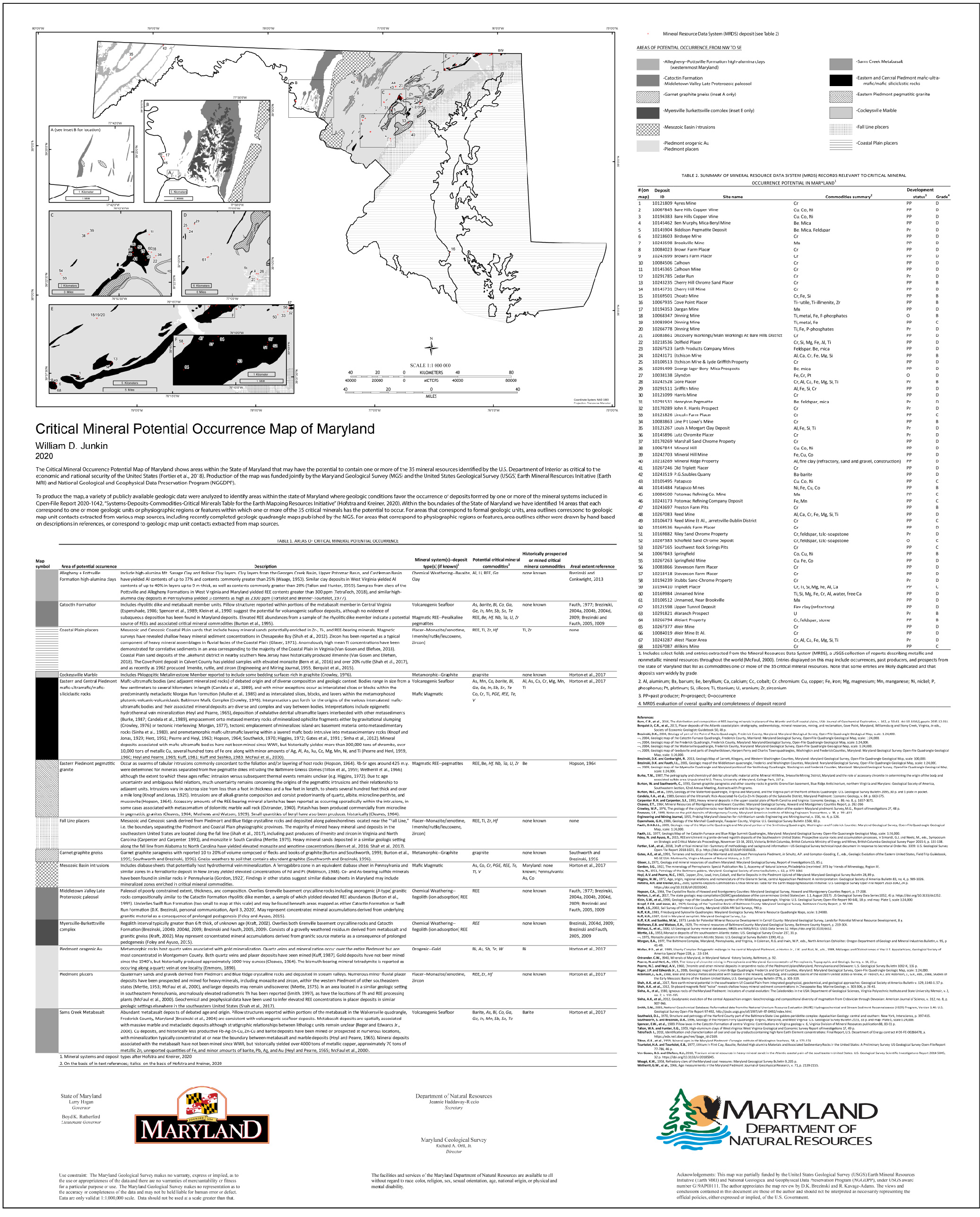
Critical Mineral Potential Occurrence Map of Maryland

The Critical Mineral Occurrence Potential Map of Maryland shows areas within the State of Maryland that may have the potential to contain one or more of the 35 mineral resources identified by the U.S. Department of Interior as critical to the economic and national security of the United States (Fortier et al., 2018). Production of the map was funded jointly by the Maryland Geological Survey (MGS) and the United States Geological Survey (USGS) Earth Mineral Resources Initiative (Earth MRI) and National Geological and Geophysical Data Preservation Program (NGGDPP). To produce the map, a variety of publicly available geologic data were analyzed to identify areas within the state of Maryland where geologic conditions favor the occurrence of deposits formed by one or more of the mineral systems included in Open-File Report 2020-1042, “Systems-Deposits-Commodities-Critical Minerals Table for the Earth Mapping Resources Initiative'' (Hofstra and Kreiner, 2020). Within the boundaries of the State of Maryland we have identified 14 areas that each correspond to one or more geologic units or physiographic regions or features within which one or more of the 35 critical minerals has the potential to occur. For areas that correspond to formal geologic units, area outlines correspond to geologic map unit contacts extracted from various map sources, including recently completed geologic quadrangle maps published by the MGS. For areas that correspond to physiographic regions or features, area outlines either were drawn by hand based on descriptions in references, or correspond to geologic map unit contacts extracted from map sources.
Critical Minerals Map
 Maryland Critical Minerals Potential Map, .pdf file (2,308 KB)

As part of the NGGDPP FY 2020 the MGS produced maps to support critical mineral resource identification in Maryland by compiling and digitizing some of the aforementioned data. The GIS maps and associated geodatabases were developed in the GeMS standard.
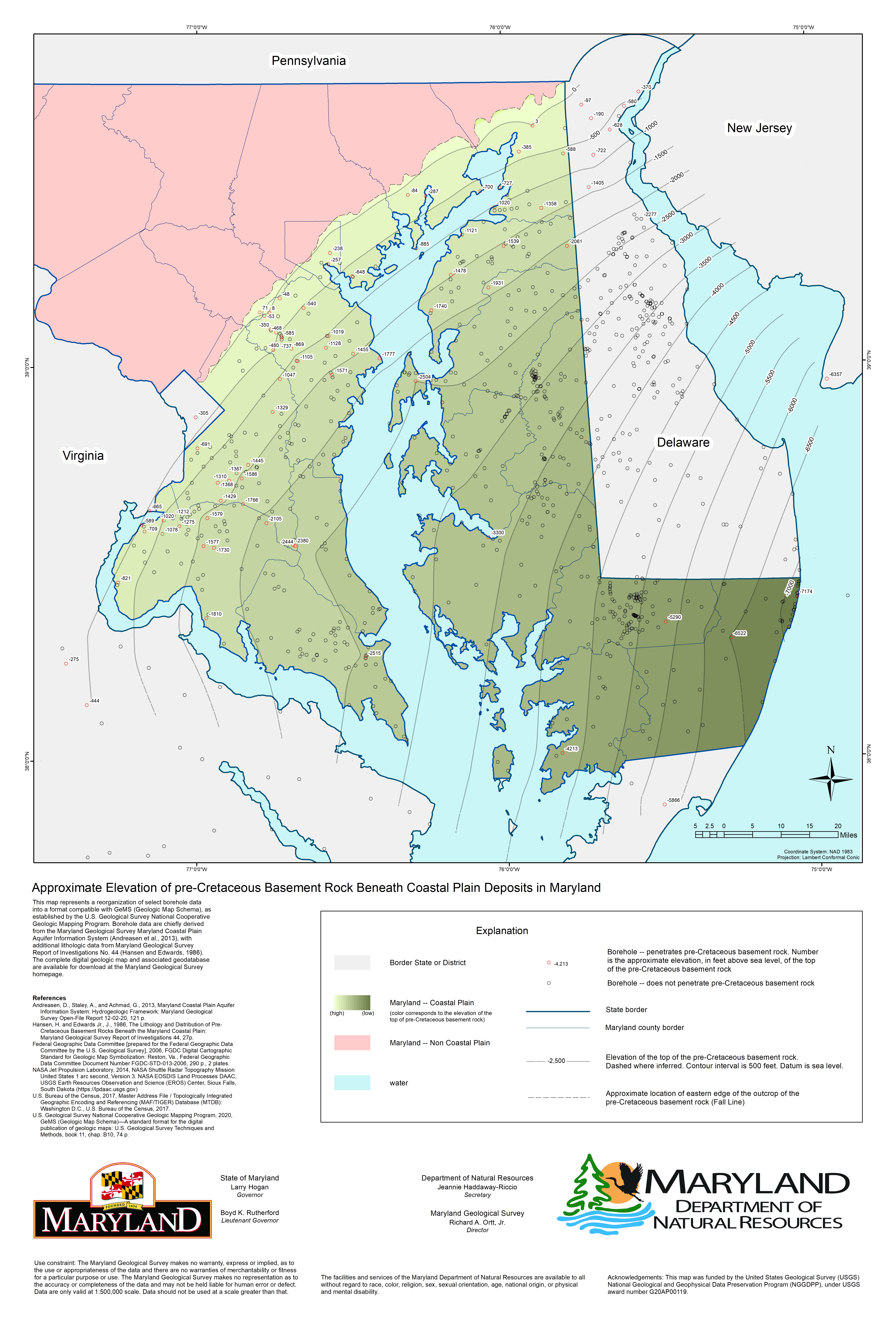
Approximate Elevation of pre-Cretaceous Basement Rock Beneath Coastal Plain Deposits in Maryland
This map represents select borehole data chiefly derived from the Maryland Geological Survey Maryland Coastal Plain Aquifer Information System (Andreasen et al., 2013), with additional lithologic data from Maryland Geological Survey Report of Investigations No. 44 (Hansen and Edwards, 1986). Borehole data has been reorganized into a format compatible with GeMS (Geologic Map Schema), as established by the U.S. Geological Survey National Cooperative Geologic Mapping Program (2020).
A contoured raster surface was generated using a natural neighbor interpolation of points of known elevation located along the Fall Line (the approximate location of the eastern edge of the outcrop of pre-Cretaceous basement rock) and of depth-to-bedrock data obtained from boreholes that were drilled through coastal plain sediments and penetrated pre-Cretaceous basement rock.
A geodatabase associated with the digital map houses borehole data including latitude, longitude, elevation, approximate depth to bedrock, total depth, bedrock lithology where available, and data used to estimate depth to bedrock (e.g. depth to bedrock, depth to saprolite, geophysical well data, presence of rock chips) is available below.
Basement Elevations Data
 Approximate Elevation of pre-Cretaceous Basement Rock, .pdf file (3,373 KB)
 Approximate Elevation of pre-Cretaceous Basement Rock, .zip file (94,038 KB)

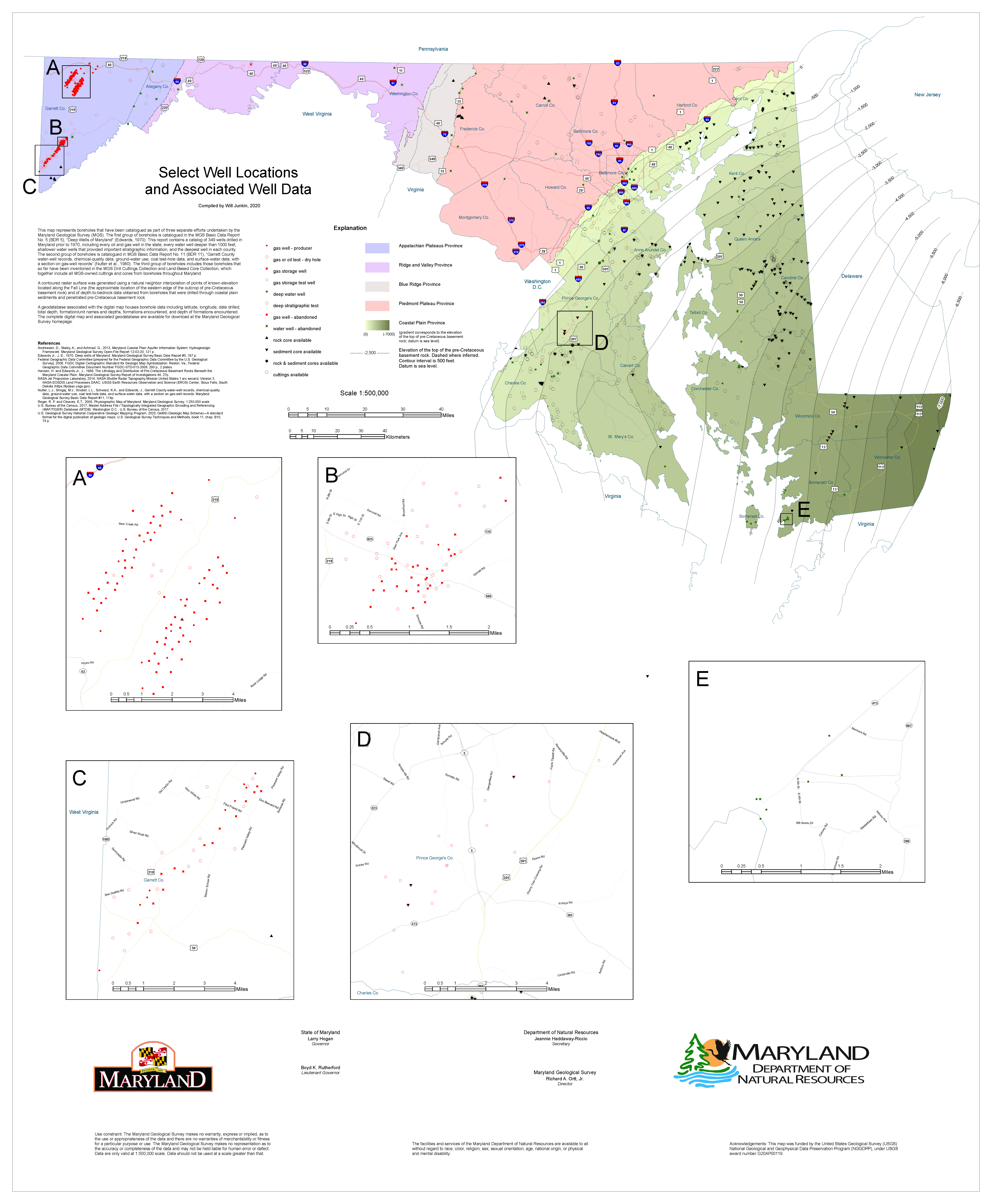
Select Well Locations and Associated Well Data
This map represents boreholes that have been cataloged as part of three separate efforts undertaken by the Maryland Geological Survey (MGS). The first group of boreholes is cataloged in the MGS Basic Data Report No. 5 (BDR 5), “Deep Wells of Maryland” (Edwards, 1970). This report contains a catalog of 349 wells drilled in Maryland prior to 1970, including every oil and gas well in the state, every water well deeper than 1000 feet, shallower water wells that provided important stratigraphic information, and the deepest well in each county. The second group of boreholes is cataloged in MGS Basic Data Report No. 11 (BDR 11), “Garrett County water-well records, chemical-quality data, ground-water use, coal test-hole data, and surface-water data, with a section on gas-well records” (Nutter et al., 1980). The third group of boreholes includes those boreholes that so far have been inventoried in the MGS Drill Cuttings Collection and Land-Based Core Collection, which together include all MGS-owned cuttings and cores from boreholes throughout Maryland.
A contoured raster surface was generated using a natural neighbor interpolation of points of known elevation located along the Fall Line (the approximate location of the eastern edge of the outcrop of pre-Cretaceous basement rock) and of depth-to-bedrock data obtained from boreholes that were drilled through coastal plain sediments and penetrated pre-Cretaceous basement rock.
A geodatabase associated with the digital map houses borehole data including latitude, longitude, date drilled, total depth, formation/unit names and depths, formations encountered, and depth of formations encountered is available below.
Well Locations Data
 Select Well Locations and Associated Well Data, .pdf file (7,054 KB)
 Select Well Locations and Associated Well Data, .zip file (93,385 KB)
CRITICAL MINERALS COLLECTION INQUIRIES
For inquiries regarding the MGS Critical Minerals Collection, please contact:
Anthony Reisinger – 410-554-5541, anthony.reisinger@maryland.gov
REFERENCES
Andreasen, D., Staley, A., and Achmad, G., 2013, Maryland Coastal Plain Aquifer Information System: Hydrogeologic Framework: Maryland Geological Survey Open-File Report 12-02-20, 121 p.
Edwards Jr., J. E., 1970, Deep wells of Maryland: Maryland Geological Survey Basic Data Report #5, 167 p.
Hansen, H. and Edwards Jr., J., 1986, The Lithology and Distribution of Pre-Cretaceous Basement Rocks Beneath the Maryland Coastal Plain: Maryland Geological Survey Report of Investigations 44, 27p.
Nutter, L.J., Smigaj, M.J., Knobel, L.L., Schwarz, K.A., and Edwards, J., Garrett County water-well records, chemical-quality data, ground-water use, coal test-hole data, and surface-water data, with a section on gas-well records: Maryland Geological Survey Basic Data Report #11, 114p.
U.S. Geological Survey National Cooperative Geologic Mapping Program, 2020, GeMS (Geologic Map Schema)—A standard format for the digital publication of geologic maps: U.S. Geological Survey Techniques and Methods, book 11, chap. B10, 74 p.
ACKNOWLEDGEMENTS
These maps and collection compilations were funded, in part by, the United States Geological Survey (USGS) National Geological and Geophysical Data Preservation Program (NGGDPP) and Earth Mineral Resources Initiative (Earth MRI) under USGS award numbers G19AP00111 and G20AP00119.
Use Constraint
The Maryland Geological Survey makes no warranty, express or implied, as to the use or appropriateness of the data and there are no warranties of merchantability or fitness for a particular purpose or use. The Maryland Geological Survey makes no representation as to the accuracy or completeness of the data and may not be held liable for human error or defect. Data are only valid at 1:500,000 scale and 1:1,000,000 scale. Data should not be used at a scale greater than those.The views and conclusions contained in these documents are those of the authors and should not be interpreted as necessarily representing the official policies, either expressed or implied, of the U.S. Government.


