


IRIS Educational Materials
| Education & Outreach Series | No. 1 |
| Watch Earthquakes as they Occur | |
|
[Located at: http://www.iris.edu (Click on the image to initiate display)] |
|
|
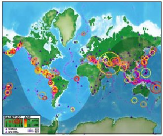
The Seismic Monitor is an interactive display of global seismicity that allows users to monitor earthquakes in near real-time, view records of ground motion, learn about earthquakes, and visit seismic stations around the world. Monitor Current Earthquakes Visit Seismic Stations View Global Topography and Seismicity Seismic Alarm |
|
IRIS is a university research consortium dedicated to monitoring the Earth and exploring its interior through the collection and distribution of geophysical data. IRIS programs contribute to scholarly research, education, earthquake hazard mitigation, and the verification of the Comprehensive Test Ban Treaty. Support for IRIS comes from the National Science Foundation, other federal agencies, universities, and private foundations. The seismic monitor was developed by the IRIS Consortium, US Geological Survey, University of Colorado, and Reel Illusions Multimedia, Inc. 1200 New York Ave., NW #800 |
|
| This educational material is reproduced with permission from the IRIS Consortium. | |
|
To obtain a copy of " Education & Outreach Series No. 1"
in Adobe PDF format, To request preprinted copies of any or all of the Education & Outreach Series, please send your request to susan@iris.edu (please include the handout volume number and quantity needed for each). |
|
|
updated 02/10/14 |
|
 , or if any seismic event is recorded from a known nuclear weapons testing
site
, or if any seismic event is recorded from a known nuclear weapons testing
site  , the
seismic alarm function is triggered.
, the
seismic alarm function is triggered.