IRIS Educational Materials
| Education & Outreach Series | No. 6 |
| How are Earthquakes Located? | |
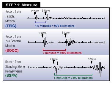
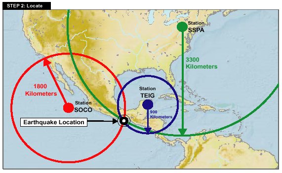
We can locate earthquakes using a simple fact: an earthquake creates different seismic waves (P waves, S waves, etc.) The different waves each travel at different speeds and therefore arrive at a seismic station at different times. P waves travel the fastest, so they arrive first. S waves, which travel at about half the speed of P waves, arrive later. A seismic station close to the earthquake records P waves and S waves in quick succession. With increasing distance from the earthquake the time difference between the arrival of the P waves and the arrival of the S waves increases. Although modern techniques are more complex, we have illustrated the basic concept using an example of an earthquake near Mexico and seismic stations in North America. The following two steps show how we determine distance from the seismograms and estimate the location using three stations.
| |
|
|
IRIS is a university research consortium dedicated to monitoring the Earth and exploring its interior through the collection and distribution of geophysical data. IRIS programs contribute to scholarly research, education, earthquake hazard mitigation, and the verification of the Comprehensive Test Ban Treaty. Support for IRIS comes from the National Science Foundation, other federal agencies, universities, and private foundations. The seismic monitor was developed by the IRIS Consortium, US Geological Survey, University of Colorado, and Reel Illusions Multimedia, Inc. 1200 New York Ave., NW #800 |
|
| This educational material is reproduced with permission from the IRIS Consortium. | |
|
To obtain a copy of " Education & Outreach Series No. 6"
in Adobe PDF format, To request preprinted copies of any or all of the Education & Outreach Series, please send your request to info@iris.edu (please include the handout volume number and quantity needed for each). |
|
|
updated 02/10/14 |
|