| Comprehensive Assessment of Water Supply in Maryland | 
|
Comprehensive Assessment of Water Supply in Maryland: Background |
||
Reasons for Studies |
||
|
The Advisory Committee on the Management and Protection of the State's Water Resources was charged with assessing the condition of the State's water resources management program, recommending steps to assure that the program will provide for the long-term use and protection of Maryland's water resources, and recommending a strategy and appropriate funding for sustainable management of these resources. In its earlier reports, the Committee addressed many of these issues. In this, its Final Report, the Committee urges the State to develop and fund a more robust, comprehensive, fully-integrated State water resources management program, and that it begin this effort by increasing staffing, making critical improvements to the monitoring program, providing for scientific assessments, and beginning the long-range planning necessary to ensure a sustainable water supply for Maryland's future. |
|
|
Regions: Atlantic Coastal Plain and Fractured Rock |
||
 |
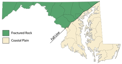
The zone where Coastal Plain sediments meet upland bedrock is called the Fall Line. It is called the Fall Line because typically, where streams cross the Fall Line there is a waterfall because of the rapid change in elevation. Many of the large cities were located along the Fall Line because of the river access to the oceans, the limitations of upstream river navigation, and a reliable supply of water power. These cities were connected by U.S. Route 1 and later Interstate 95, which runs southwest-northeast through the state and is the approximate division between the Coastal Plain to the east and the Fractured Rock regions to the west. | |
Fractured Rock |
||
(modified from "Heath, Ralph C., 1984, Ground-water regions of the United States, USGS WSP 2242") |
The Fractured Rock region is divided into four physiographic provinces including the Piedmont, Blue Ridge, Ridge and Valley, and Appalachian Plateau. Water availability in the fractured rock region is localized and depends upon the size of fractures and interconnections between fractures. Much of the groundwater is stored in weathered bedrock, or saprolite, which overlies the solid rock. In terms of supply, the fractured rock aquifers are highly irregular in both distribution and storage, and are strongly tied to climatic influences due to their shallow depth.
Sideling Hill roadcut, Interstate 68 |
|
Coastal Plain |
||
 |
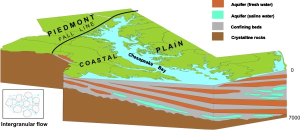
In the Coastal Plain, groundwater in the sand and gravel aquifers is the primary source of water supply. The sand and gravel layers alternate with layers of silt and clay that form a wedge-shaped system of sediments that begin at the Fall Line. The Coastal Plain aquifers are likely to be affected by climate change, but indirectly. Much of the Coastal Plain groundwater currently being withdrawn is from deep, confined aquifers, meaning that the water supplying your house may have infiltrated thousands of years prior. Therefore, the stress on these aquifers during drought periods will be due to increased withdrawals by farmers, homeowners, and others rather than reduced precipitation.
Layered Miocene sediments at Calvert Cliffs |
|